Todos los países / Reino Unido / England / Perimeter road, Defford Airfield
Perimeter road, Defford Airfield
Aeródromo · Reino Unido
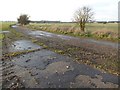
Perimeter road around the eastern boundary of the former RAF Defford Airfield which was constructed in 1941 and became important in the development of RADAR. The airfield closed in 1957. The land is now farmed and West Mercia Constabulary occupy part of the site as well as a satellite communicatio
- Tipo
- Aeródromo
- País
- Reino Unido
- Cerca de
- Tewkesbury
En el mapa se indican la ubicación exacta, cómo llegar, el tiempo y los lugares de los alrededores.
Otros lugares cercanos
- Upper Soudley Halt railway stationEstación de tren
- Ruddle Road Halt railway stationEstación de tren
- Chedworth Halt railway stationEstación de tren
- Speech House Road railway stationEstación de tren
- Newnham railway stationEstación de tren
- Ruspidge Halt railway stationEstación de tren
- Bilson Halt railway stationEstación de tren
- Drybrook Road railway stationEstación de tren